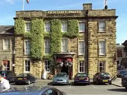
The Old Hall Hotel - Hope
Over 200 views on venues4hire.org

The Old Hall Hotel - The Old Hall Hotel
To make a booking or enquire about hiring this venue please use the contact details below - Please mention Venues for Hire
01433 620160
Bookings Administrator
Use contact form below
The Old Hall Hotel description
Hotel / Conference Centre
Medium (1-150)
Hope is a village of great antiquity lending its name to the Hope Valley, which stretches for about six miles with Castleton at one end and Hathersage at the other. There is evidence that Hope has been extremely significant in the region throughout its long history. The village is mentioned in the Doomsday book, of 1086, as having both a priest and a church, the only place in north Derbyshire to have such status at the time. St. Peters Church, opposite the Old Hall, dates from around the 13th Century.
The parish of Hope covered two thirds of the Royal Hunting Forest of north Derbyshire and was one of the largest parishes in the country. From earlier times there are traces of a Roman fort at Brough, just to the east of the village. Its Roman name Navio was later replaced with the Old English word for fort, Brough. Many ancient relics from the site can be seen in Buxton museum. It is thought that the fort was probably built to protect Roman lead mining interests in the Peak District.
The village is built on the crossroads of the A625, Sheffield to Chapel-en-le-Frith road, and the B6049 that runs northward from Tideswell to Edale. This minor road closely follows the route of the old Portway, which was an ancient trading route used by Jaggers, a local term for men driving packhorses carrying salt and other goods from Cheshire. Names like Saltergate Lane and Jaggers Lane probably originate from this period.
Venue suitability
This venue is suitable for the following uses:
Venue facilities
Other venue facilities
We don't currently hold any detailed information about the rooms at this Venue.
If this is your Venue or Hall please use the Adopt link on the right to add more detailed information about this Venue.
If you wish to hire this Venue or Hall please use the contact details on the overview tab.
Please encourage every Venue to take a few minutes to 'Adopt' their listing and add unique content and photos.
